 So, last time, we talked about what a front is, and how we define a front. But, all those lines on your local weather map aren't all the same, as evidenced by the different colors and symbols.
What types of fronts are there?
Find out after the jump!
Warm Front
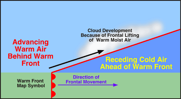
As I mentioned last time, meteorologists name fronts by what air is advancing. Under this naming convention, a warm front occurs when a warm air mass (usually tropical in origin) advances upon a colder air mass. However, since warm air rises, the warm air flows over the cold air while pushing it along as well. Because of the slowed rising motion, warm fronts are often very shallow, extending over a large horizontal distance.
In addition, this warm air is also often moist, so it condenses its water vapor out as it rises, forming clouds, as well as rain, sleet, or snow (generally known as precipitation). When combined with the shallowness of the front, warm fronts are often characterized by a large swath of precipitation that sits in advance of the actual surface front, which is denoted by a red line with semicircles in the direction of motion on your local meteorologist's weather map.
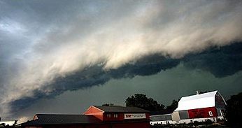
Cold Front

In response to being undercut, the warm, moist air is forced to rise quickly upward, resulting in the large cumulonimbus (thunderhead) clouds often associated with thunderstorms. Therefore, cold fronts often bring about a meteorologist's favorite variety of weather: severe weather. Thunderstorms, hail, and tornadoes are usually caused by the passage of a cold front, making it the most dangerous of any front type. The surface cold front is designated by a blue line with triangles pointing in the direction the front is moving.
Occluded Front
 While it may only seem that only warm and cold air masses could advance on each other and cause fronts, they can also combine together, to cause occluded fronts. In an occluded front, a trailing cold front catches up to the warm front. Colder air behind the entire air mass causes lifting of both the warm and cool air in the warm front, giving rise to a hybrid of the two fronts, which can be wider swaths of precipitation, along with some embedded thunderstorms, especially toward the surface front. Occluded fronts are designated by a (often) purple line that has both triangles and semicircles in the direction of the front's movement, indicating its hybrid nature.
Stationary Front

Well, there you have it! The basic four frontal types. Hopefully, your local meteorologist is a little easier to understand the next time they come on the nightly news!
No comments:
Post a Comment