The Atlantic Basin has been rather quiet late in this year's hurricane season (which runs from late May - November 30th), only producing two named storms in the past month. In fact, the Atlantic Basin has been completely quiet for 10 days now, which is not altogether unexpected, especially as we reach the end of the season.
In the Eastern Pacific, it's a whole other story. While the season overall has been quiet, Hurricane Kenneth is setting records as we speak. Forming out off the western coast of Mexico on the 19th of November, it was the latest forming named storm since 1983. Meanwhile, Kenneth has unexpectedly strengthened into a category 4 major hurricane on the Saffir-Simpson Scale, with sustained winds of 145mph, becoming the latest forming major hurricane, and strongest late-season storm since the satellite era began in the 1960s.
Thankfully, Kenneth is forecast to stay away from land and dissipate over the next few days, which is the best news for both concerned citizens and storm watchers, as both win out in this situation.
After the jump: forecast and satellite image for Hurricane Kenneth!
Tuesday, November 22, 2011
Monday, November 21, 2011
The Back-Story on Fronts, Part 2
 So, last time, we talked about what a front is, and how we define a front. But, all those lines on your local weather map aren't all the same, as evidenced by the different colors and symbols.
What types of fronts are there?
Find out after the jump!
Sunday, November 20, 2011
The Back-Story on Fronts, Part 1
 So you turn on your TV, and your local meteorologist shows you the current weather map. And there's all sorts of red and blue (and sometimes even purple!) lines on the screen. It's not like you can go outside, look up, and see a thick blue line crossing overhead.... so what do they stand for?
Short answer: They signify where a frontal zone is located.
Now I can hear you saying, "But what exactly is a front?" Find out after the jump!
Thursday, November 17, 2011
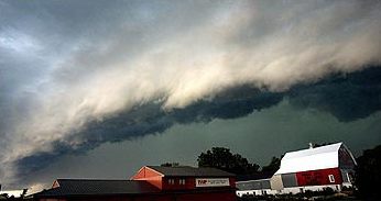
The Unusual Case of Undulatus Asperatus

Classifying clouds isn't exactly the most exciting thing that comes to mind when weather is discussed with friends, or in the elevator. And cloud classification is not the most modern of sciences, especially with National Weather Service offices in the United States no longer required to report cloud type in their hourly observations. In fact, the last time the World Meteorological Organization (WMO) officially recognized a new cloud formation, Harry Truman was president. In 1951, they added Cirrus intortus to the official list of cloud formations. Now the WMO is thinking about reopening the dusty pages of the International Cloud Atlas (yes, there is an atlas of clouds) for the first time in 60 years.
Subscribe to:
Posts (Atom)